Must Read
Illustration from Javadi et al. (2015), showing how the Arabian Plate is colliding with the Eurasian Plate, producing the Zagros and other mountain belts in IranIllustration from Javadi et al. (2015), showing how the Arabian Plate is colliding with the Eurasian Plate, producing the Zagros and other mountain belts in Iran
Hormuz Strait is closing
For feedback or concerns regarding this content, please contact us at [email protected]
Since the war started in late February with the launch of Operation Epic Fury, the back-and-forth of opening and closing the Hormuz has not stopped. In reality, the strait, together with the Persian Gulf and the Gulf of Oman, has been closing and will continue to do so — geologically.
The Strait of Hormuz is a narrow body of water that separates countries sitting on different tectonic blocks. The narrowest section — where the Sultanate of Oman (Oman) which rides on the Arabian Plate, is separated from the Islamic Republic of Iran (Iran) which sits at the southern edge of the Eurasian Plate — is only around 21 nautical miles (roughly 40 kilometers) wide.
The strait connects the Persian Gulf and the Gulf of Oman, with the latter eventually exiting into the open Arabian Sea. These waterways serve as major channels to transport petroleum products from the oil producing countries of the Middle East and South Asia, among others.
Collision in Iran
The theory of plate tectonics supposes that the crust (lithosphere, more technically), the outermost layer of the Earth, is composed of numerous broken pieces called plates that interact with each other. When two plates move away from each other, they are said to spread apart. At present, areas of tectonic spreading are found in the Atlantic Ocean, East Pacific Rise, Indian Ocean, but also in the Great African Rift.
When two plates move toward each other, either subduction or collision takes place. In subduction, a denser plate slides underneath another which is lighter. Subduction usually produces chains of volcanoes, such as those that comprise the Philippine archipelago.
Collision occurs when the two plates have similar densities. It produces tall mountain ranges such as the Himalayas where the Indian Plate and Eurasian Plate, both of continental nature, bang against each other.
Think two colliding vehicles head-on, the crumpled hoods would be analogous to mountain peaks and valleys. In a similar manner, the Zagros Mountains of southwestern Iran are the result of the collision between the Arabian Plate and the Eurasian Plate. This happens because the Arabian Plate is moving northwards at an average rate of two-and-a-half centimeters per year (2.5 cm/yr) in the direction of Iran (see illustration). For comparison, fingernails grow at around four centimeters in a year (4.0 cm/yr).
The Persian Gulf, which separates much of the Kingdom of Saudi Arabia (Saudi Arabia) and Iran, is a waterbody produced by the depression of the northern edge of the Arabian Plate as it is pushed down by the weight of the Iranian continental block, even as the former pushes northwards against the latter. In this manner, the Persian Gulf is getting narrower (closing).
At the Strait of Hormuz, it is estimated that the northern tip of Oman will eventually stick with the island of Hormoz in southeastern Iran in about 1.6 million years. By then, the strait will be entirely closed.
Petroleum endowment
But it is also by virtue of this tectonic collision that Iran is endowed with prolific petroleum deposits.
A conventional petroleum system consists of four basic components: hydrocarbon source, pathways of hydrocarbon migration, reservoir rock and seal that caps off the system.
Oil and natural gas are composed of compounds called hydrocarbons. Hydrocarbons consist mainly of hydrogen and carbon atoms. Methane, consisting of four atoms of hydrogen attached to a single atom of carbon, hence the chemical formula CH4, is the simplest form of a hydrocarbon. A more complex form is Butane (C4H10), a highly flammable fluid that when pressurized into gas, provides flame to flint lighters.
To become economically viable petroleum deposits, these hydrocarbons need to accumulate and be trapped in significant amounts in reservoir rocks at particular locations. Among the best petroleum traps are in fold and fault belts located in collision zones, like those in the Zagros Mountains of southwestern Iran.
The underside of a fold plays as an inverted cup to trap the hydrocarbons. Pipes are then drilled into the inverted cup to extract the petroleum. Hydrocarbons are derived from organic-rich rocks exposed to elevated pressure and temperature conditions. Organic compounds are incorporated into sediments in large quantities in ocean basins where flora and fauna are flourishing.
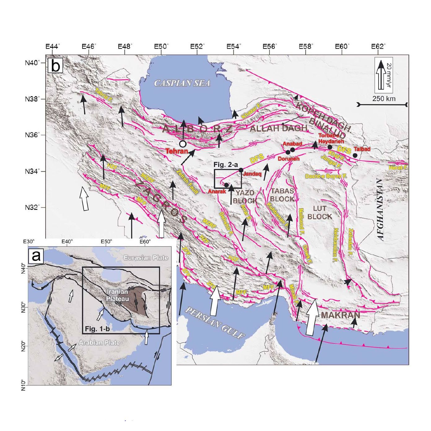 Illustration from Javadi et al. (2015), showing how the Arabian Plate is colliding with the Eurasian Plate, producing the Zagros and other mountain belts in Iran and vicinity. Arrows indicate the rate and direction of tectonic plate motions at certain locations.
In what would become the present-day Middle East, this was the scenario during the Mesozoic Era, the geological period when dinosaurs roamed the Earth between 250 and 65 million years ago. By the Palaeocene, the first epoch of the Cenozoic Era around 55 million years ago, the Arabian Plate that contained the Mesozoic sediments that have lithified into rocks after being buried by younger layers of sedimentary deposits, started splitting away from the African Plate giving rise to the formation of the Red Sea in between.
This northward motion of the Arabian Plate, which continues today, commenced the Arabian-Eurasian plates collision giving rise to the petroleum-rich Zagros mountain belt.
Strait of Humankind
While the Strait of Hormuz continues to close by a few centimeters per year by virtue of plate tectonics, 1.6 million years after full closure is plenty of time for the present-day Earth dwellers — we humans — to take advantage of.
International maritime laws require that such water bodies should allow freedom of navigation, especially when the commodities transported through them are crucial to sustain world economies.
This sea lane must remain open for the sake of world order and peace. – Rappler.com
Mario A. Aurelio, PhD, is a professor at the National Institute of Geological Sciences-University of the Philippines, and faculty head of the Structural Geology and Tectonics (SGT) Laboratory of this institute. Among his interests include research on geodynamics — how the earth has evolved in time — and the role of geologic structures in the formation of petroleum deposits.
Market Opportunity
ArchLoot Price(AL)
$0.001517
$0.001517$0.001517
USD
ArchLoot (AL) Live Price Chart


Disclaimer: The articles reposted on this site are sourced from public platforms and are provided for informational purposes only. They do not necessarily reflect the views of MEXC. All rights remain with the original authors. If you believe any content infringes on third-party rights, please contact [email protected] for removal. MEXC makes no guarantees regarding the accuracy, completeness, or timeliness of the content and is not responsible for any actions taken based on the information provided. The content does not constitute financial, legal, or other professional advice, nor should it be considered a recommendation or endorsement by MEXC.
You May Also Like

The changing face of elder care in Malaysia — Sayed Mohammad Reza Yamani Sayed Umar
JULY 10 — An elderly society is becoming increasingly prevalent in Malaysia at present. It is projected that the p...
Share
Malaymail2026/07/10 15:24
Not a loophole: Singapore AI export controls let China tap US AI legally
American AI technology is reaching Chinese tech giants through a route that US export controls were never designed to close: Singapore. The city-state sits outside
Share
The Cryptonomist2026/07/10 14:46

Exclusive interview with Smokey The Bera, co-founder of Berachain: How the innovative PoL public chain solves the liquidity problem and may be launched in a few months
Recently, PANews interviewed Smokey The Bera, co-founder of Berachain, to unravel the background of the establishment of this anonymous project, Berachain's PoL mechanism, the latest developments, and answered widely concerned topics such as airdrop expectations and new opportunities in the DeFi field.
Share
PANews2024/07/03 13:00