Typhoon Domeng on its way out of PAR but enhancing southwest monsoon
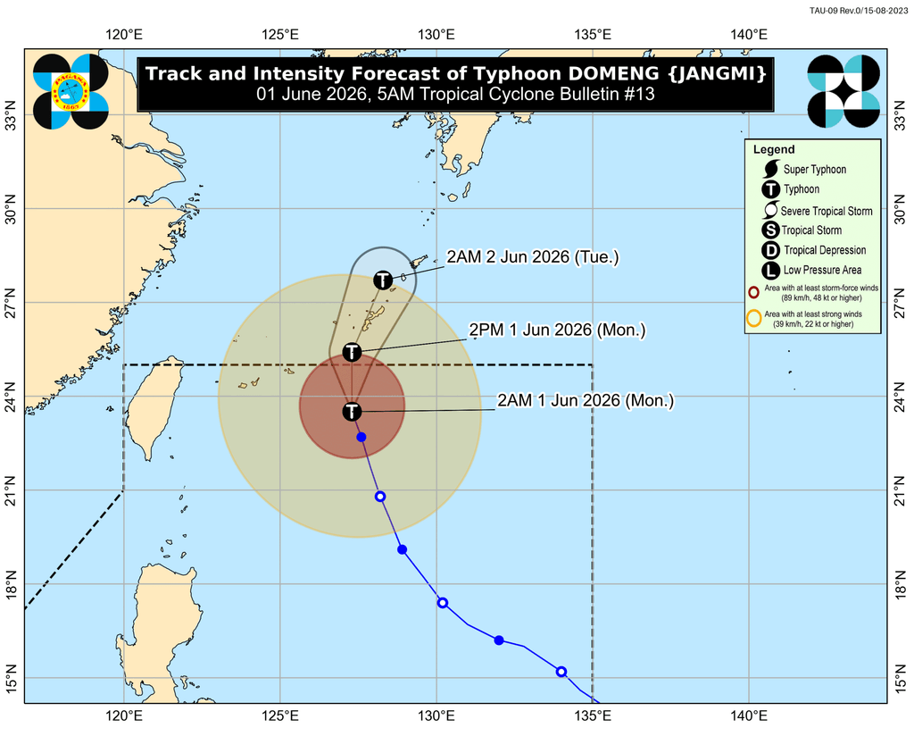
MANILA, Philippines – Typhoon Domeng (Jangmi) is already set to leave the Philippine Area of Responsibility (PAR) on Monday morning or afternoon, June 1, but it continues to enhance the southwest monsoon or habagat, which is affecting Southern Luzon, Central Luzon, and Western Visayas.
As of 4 am on Monday, Domeng was located 655 kilometers east northeast of Itbayat, Batanes, moving north northwest at 15 kilometers per hour (km/h). It has stayed over the Philippine Sea, far from landmass.
Domeng maintained its strength, with maximum sustained winds of 130 km/h reached on Sunday, May 31, and gustiness of up to 160 km/h.
The trough or extension of the typhoon is no longer affecting parts of the country on Monday, according to the Philippine Atmospheric, Geophysical, and Astronomical Services Administration (PAGASA).
But the enhanced southwest monsoon is bringing scattered rain and thunderstorms to Metro Manila, Calabarzon, Bicol, Mimaropa, Central Luzon, and Western Visayas.
Rain from the enhanced southwest monsoon is seen to be heaviest in these areas:
Monday, June 1
- Moderate to heavy rain (50-100 millimeters): Palawan, Occidental Mindoro
Tuesday, June 2
- Moderate to heavy rain (50-100 mm): Bataan, Palawan, Occidental Mindoro
Wednesday, June 3
- Moderate to heavy rain (50-100 mm): Zambales, Bataan
Floods and landslides are possible.
There are no tropical cyclone wind signals in effect. But the enhanced southwest monsoon and the periphery or outer bands of the typhoon will bring strong to gale-force gusts to these areas:
Monday, June 1
- Batanes, Babuyan Islands, Metro Manila, Calabarzon, Mimaropa, Bicol, Panay Island, Negros Occidental
Tuesday, June 2
- Batanes, Babuyan Islands, Central Luzon, Metro Manila, Calabarzon, Mimaropa, Camarines Norte, Camarines Sur
Wednesday, June 3
- Ilocos Sur, La Union, Pangasinan, Isabela, Central Luzon, Metro Manila, Calabarzon, Mimaropa, Camarines Norte, Camarines Sur
On Monday, conditions in certain seaboards remain dangerous for small vessels.
Up to rough seas (small vessels should not venture out to sea)
- Eastern seaboard of Batanes – waves up to 3.5 meters high
- Seaboards of mainland Cagayan and Isabela; northern and eastern seaboards of Babuyan Islands; remaining seaboard of Batanes – waves up to 3 meters high
Up to moderate seas (small vessels should take precautionary measures or avoid sailing, if possible)
- Northern and eastern seaboards of Polillo Islands and Catanduanes; northeastern seaboard of Aurora; northern seaboards of Camarines Norte and Camarines Sur – waves up to 2.5 meters high
- Remaining seaboard of Aurora; northern seaboard of Ilocos Norte; northern and eastern seaboards of Northern Samar; eastern seaboards of Sorsogon and Eastern Samar; seaboards of Kalayaan Islands; western seaboard of southern Palawan – waves up to 2 meters high
Domeng is the Philippines’ fourth tropical cyclone for 2026, and the second for May.
PAGASA is expected to soon declare the start of the rainy season, which typically begins in the second half of May or the first half of June. – Rappler.com

You May Also Like

StakeStone (STO) Rockets 125%: What $981M Trading Volume Reveals

The Chemistry of UV Resistance: How Titanium Dioxide Protects Against the California Sun
'Catastrophe': Trump slammed with lawsuit over 'abhorrent' conditions at ICE facility